Paris Rive Gauche
![]() 13ᵗʰ arrondissement
13ᵗʰ arrondissement

🇬🇧 This journey has been automatically translated from its original french version. The translation may be inaccurate.
Located in the left bank of the Seine – on the edge of the 13ᵗʰ arrondissement – the Paris Rive Gauche district is an urban planning project initiated in 1991, which is still under construction. Immerse yourself in a district of Paris which has lived through architectural and urban planning projects for over 40 years and keep transforming today.

This journey was created in partnership with the CAUE of Île-de-France and with the support of the Direction Régionale des Affaires Culturelles, as part of the « Archipel Francilien » collection.

Want to discover the journey ?
For total immersion, download our app and start the journey now!
Journey preview
A new district on the bank of the Seine
 Panoramic view, taken from the Bercy Bridge, Charles Lansiaux, September 21, 1916 © VDP / BHVP
The part of the 13ᵗʰ arrondissement on which the Paris Rive Gauche project is being developed was formerly occupied by industrial land and railway lines. The project has kept traces of this industrial past, with the conservation of old buildings finding a new use in the neighborhood.
 © Martin Argyroglo
In the 90s, this project made it possible to test a new way of building the city. Even today, it is the subject of calls for innovative projects leading to re-questioning the traditional heights of buildings or even to imagining a travel architecture around short food circuits. The completion of this new 130-hectare piece of town on the left bank of the Seine is planned for 2030, almost forty years after the approval of the operation by the Paris Council in 1991. .
A new district on the bank of the Seine
Panoramic view, taken from the Bercy Bridge, Charles Lansiaux, September 21, 1916 © VDP / BHVP
The part of the 13ᵗʰ arrondissement on which the Paris Rive Gauche project is being developed was formerly occupied by industrial land and railway lines. The project has kept traces of this industrial past, with the conservation of old buildings finding a new use in the neighborhood.
© Martin Argyroglo
In the 90s, this project made it possible to test a new way of building the city. Even today, it is the subject of calls for innovative projects leading to re-questioning the traditional heights of buildings or even to imagining a travel architecture around short food circuits. The completion of this new 130-hectare piece of town on the left bank of the Seine is planned for 2030, almost forty years after the approval of the operation by the Paris Council in 1991. .
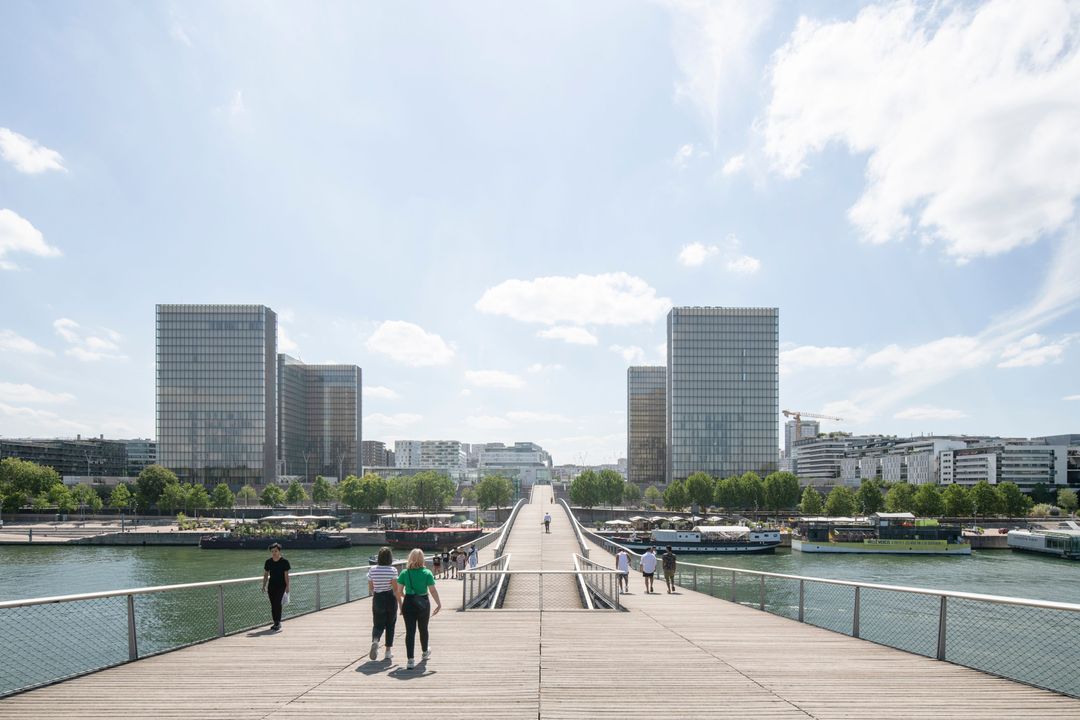
Simone-de-Beauvoir footbridge
 © Martin Argyroglo
This structure, formerly named the Bercy-Tolbiac footbridge, was built in 2006, eleven years after the Bibliothèque nationale de France (National Library). It made it possible to continue the opening of the district by connecting two districts separated by the Seine, and the different levels of the esplanade, the quay and the port.
This is the 4ᵗʰ footbridge crossing the Seine in Paris, after the Passerelle des Arts, the Passerelle Debilly and the Passerelle Léopold-Sédar-Senghor (formerly Solférino).
The architect Dietmar Feichtinger has created a work incorporating the arch which forms the common identity of the city's bridges. The arch and chain of the bridge form a lens, creating a place suspended above the river.
 © Martin Argyroglo
Prefabricated in Alsace, the 105 meters long central lens had to be transported via canals, the North Sea and the English Channel, before reaching its location via the Seine. It is hoisted in just 2 hours.
Walkers are encouraged to stop and observe the urban landscape from the footbridge. The passage is reserved for gentle mobility. Its connection to the quays from the esplanade offers passers-by access to festive atmospheres, the polar opposite of past industrial activity.
Bibliothèque François-Mitterrand
During his televised speech on July 14, 1988, the President of the Republic François Mitterrand announced the “construction and development of one or the largest and most modern library in the world”. After examining several locations, including in the suburbs and in the provinces, Tolbiac was chosen to host this new site of the National Library of France.
La Très Grande Bibliothèque
 © Martin Argyroglo
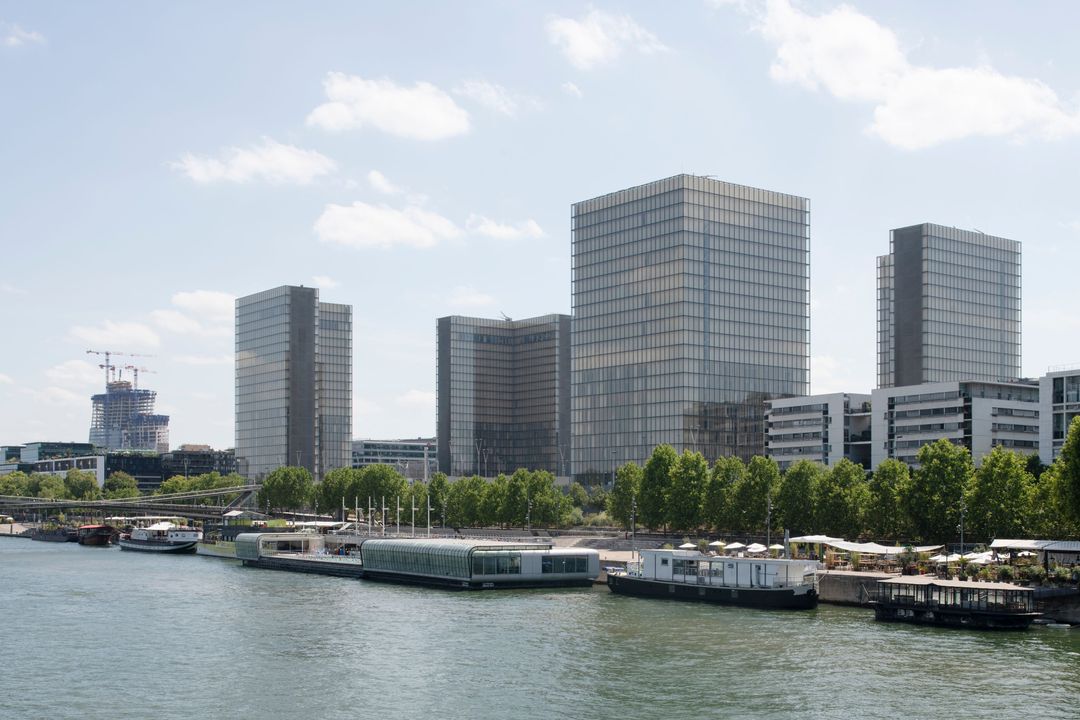
At the time of the construction of the Bibliothèque Nationale de France and the housing surrounding it, there was still significant industrial activity on the quays and Avenue de France remained unfinished. The location of the future “Très Grande Bibliothèque” (Very Great Library) is then occupied by an SNCF (french national railway company) goods station.
The project by architect Dominique Perrault, which won over 250 other proposals, participated in the founding of Paris Rive Gauche. Opened to the public in 1997, the library occupies an entire block, more than 250,000 m² on different levels and an interior garden. The four towers, like large open books, frame a generous esplanade accessible from all sides.
80 meters high, each has a name: tower of numbers, tower of laws, tower of times and tower of letters. Most of the floors are allocated to the storage of books and documents. There are 14 million books and 400 linear kilometers of shelves!
The upper floors house technical rooms and the lower floors administrative offices. Wooden shutters and a large air conditioning system ensure the good conservation of the works. If they are thus stored in these large glass towers and not in underground storage spaces, it is to make visible all the knowledge they contain and to make it accessible to all.
The forest garden
 © Martin Argyroglo
The reading rooms are located in the basement, all around the large central patio which houses a one-hectare “forest garden”. The upper garden welcomes readers and the public, while the garden level only receives authorized researchers. Prohibited from access, the garden is designed like a cloister or a Japanese garden which you can walk around without disturbing the peace and quiet. While we contemplate the summit from the esplanade, we find ourselves under its foliage when we sit in one of the reading rooms.
If some trees are already so large, it is because they were transplanted to reconstitute a forest as soon as the library was inaugurated. 126 adult Scots pines from Normandy were replanted, alongside other plants and younger specimens, to recreate a natural space set to develop. Today it is a bird refuge and the fauna and flora it shelters contribute to establishing an urban green network in Paris.
This project caused a lot of debate at its origin, with some predicting a cold and disproportionate construction. Finally, the esplanade now hosts many uses, and is an essential place in the neighborhood.
In 2012, a new portal was added by the architect to the east entrance.
▶️ Discover the interior garden construction site in this report from 1994 available on the INA website.
More content
Avenue de France
 © CAUE de Paris - J-B Vicquelin
Here is the main artery of the Paris Rive Gauche operation, completed in 2012. Like the buildings which line it (some still under construction), this new route is built on a slab above the railways which lead to Austerlitz station. The most important works of Paris Rive Gauche are therefore under your feet, where it was necessary to build important infrastructures capable of supporting the load of a new district.
Thus, most of the buildings on the other side of the track are “bridge buildings”: they rest on enormous reinforced concrete beams which cross the railway tracks. Even today, this work continues at night to avoid disrupting train and RER C traffic. At the ends of Avenue de France, you can see the construction of the slabs above the railway tracks.
1750 meters long, Avenue de France stretches from Boulevard Vincent Auriol, where this route begins, to the Tours Duo which can be seen to the south. Beyond that is the limit of the ring road and the town of Ivry-sur-Seine.
More content

Les Frigos (The Fridges)
 © Martin Argyroglo
A remaining industrial heritage
At 19 rue des Frigos, we find the building of the old cold storage warehouses, created in 1921. Trains entered directly inside the building to deposit the goods stored there. In 1971, industrial activity ceased following the relocation of Les Halles de Paris.
Artists quickly took over the premises. The conservation of this building, which had become an industrial wasteland, was not planned in the Paris Rive Gauche project. The City of Paris finally decided to perpetuate the artistic activity that took place for almost thirty years within the building, by officially making this place a space for creation and development. Today, more than 200 professionals occupy these premises.
🎧 Interview (in french) with Jean-Paul Réti, sculptor and president of the association Les Frigos APLC 91. Directed by Fanny Rahmouni.
Parc des Grands Moulins
 © Martin Argyroglo
Public spaces for everyone
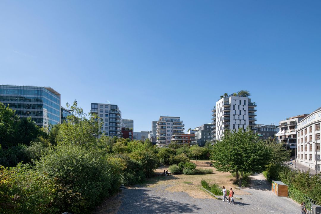
Unlike the old industrial district where the development was designed to encourage economic activity, Paris Rive Gauche favors the development of public spaces and green spaces. Among them, the jardin Abbé-Pierre - Grands Moulins has an area of 12,000 m².
It includes three spaces: the central garden made up of natural flower meadows, a square and a terrace, the Avenue-de-France garden equipped with collective games, and the School garden intended for young people with play areas. An aerial footbridge allows you to cross the park outside its opening hours. It creates the link between rehabilitated industrial buildings and new buildings built above the rails.
▶️ Interview (in french) with Ludovic Vion, from the Société Mixte d’Aménagement de Paris (SEMAPA). Directed by Fanny Rahmouni.
Former Grands Moulins
 © Martin Argyroglo
Preserve the spirit of the place
For 80 years and until 1996, the Grands Moulins de Paris housed a flour mill, where flour and cereals delivered to companies were prepared. From the start of the Paris Rive Gauche project, the buildings benefited from architectural classification which ensured their conservation.
When industrial activity moved to Gennevilliers, the main building was transformed by Rudy Ricciotti, architect of the university site. The building houses the administrative services and the literature, sciences and humanities library of Paris-Diderot University. It retains its mansard roofs and its neoclassical facade. Concrete mesh now covers the windows. Inside, the vertical structure and certain floors have been preserved; others were destroyed in order to open up this formerly closed-off place.
More content
Open island
 © CAUE de Paris
A new kind of urban planning
From the start of the development operation, the 130 hectares of Paris Rive Gauche were divided into four large sectors, themselves divided in two by the axis of Avenue de France, for a total of 8 districts. The design of each of these districts was entrusted to an architect-coordinator to establish the main urban principles.
Here, it is the architect Christian de Portzamparc who developed the Masséna-Nord district around an innovative concept: the open island.
To arrive at this concept, the architect first defined two “ages” which previously existed in the design of the city before proposing a third:
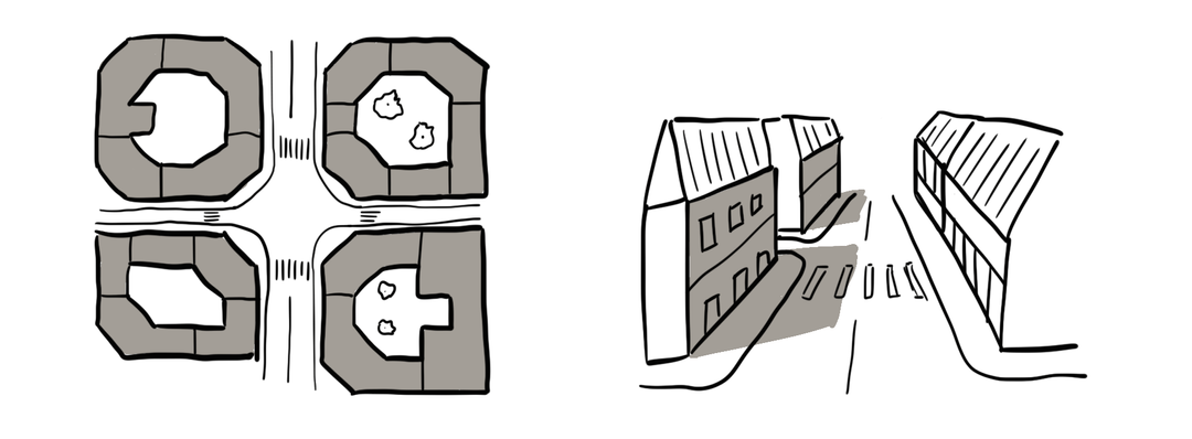
- The closed block and its corridor streets, as we encounter it in the Haussmannian or Faubourian neighborhoods of Paris;
 2. The open plan, such as large complexes: an urban planning of bars and towers placed on a free plan, without alignment with the street;
 3. The open block where the facades of the buildings are aligned with the street but without strict continuity. The height is capped but the shapes can vary, allowing light and views to flow through the streets and the hearts of the blocks.
This urban planning has several advantages, according to its designer:
- The streets, the city's living arteries, are preserved but openings in the blocks create views and gardens from the public space;
- The buildings, separated from each other, can seek light and views from all their facades. Housing can thus have several orientations;
- Freed from joint ownership, these facades can be freely designed by architects, facilitating the expression and cohabitation of different styles and programs (housing, offices and university).
The result is observed through the diversity of rhythms, shapes and colors that make up the streets, but also by the visual breakthroughs that cross the blocks, making the gardens of the private courtyards visible from the streets.
INALCO BULAC building
 © Martin Argyroglo
Connecting the different levels of the neighborhood
From the beginning, the project planned to cover the railway tracks because it was impossible to eliminate them. A large concrete slab capable of supporting new construction was therefore built.
The INALCO BULAC building forms the link between the different levels of the district, where the historic urban fabric and the project meet.
The level of the slab corresponds to rue des Grands Moulins. Rue du Chevaleret, which existed before the project and ran alongside the railway tracks, corresponds to the historic ground level. The brick facade of the building is punctuated by patios reminiscent of the HBM buildings facing it on rue Cantagrel. An overhang marks the building and the connection between the different levels and eras of the district.
La Cité-Refuge de l'Armée du Salut
 © Martin Argyroglo
The building was built in 1933, when the 13ᵗʰ arrondissement of Paris was still very industrial. Its neighbors were therefore low industrial buildings and faced the large bundle of rails. It was a time when France was going through a major economic crisis and during which many people were desperate for housing. Managed by the Armée du Salut (Salvation Army), this building houses and works for the social integration of 500 men and women in need.
It is the first large-scale building created by Le Corbusier who had then designed mainly individual houses. This building implements all the major principles of modern architecture. It shares the plot with the INALCO building and a garden links the two.
Masséna Station
 © Martin Argyroglo
From farm to fork!
Masséna station, built in 1863, is a former station of the inner ring road, then the RER C. It straddles the tracks of the inner ring road, the slab welcoming the Paris Rive Gauche district and the former level of the streets of the neighborhood.
In 2014, the City of Paris launched a call for innovative urban projects “Réinventer Paris” (Reinventing Paris) to developers, investors and designers from around the world. Each team presented their ideas and the winners were chosen in 2016. The winning team's project for the former Masséna station proposes to bring together all aspects of food in a central location. We will be able to explore a complete cycle on a daily basis: production – transformation – marketing in a vertical “micro-city” in the form of a tower.
🎧 Interview (in french) with Lina Gotmeh, project architect. Directed by Fanny Rahmouni.
Bruneseau district
 © CAUE de Paris - J-B Vicquelin
The last part of Paris Rive Gauche, the Bruneseau district has its share of challenges. It must create the seam between Paris and Ivry, while dealing with the numerous infrastructures that cross it: the railways, the boulevard, the interchange and the boulevard périphérique.
Its first stone is the hôtel industriel Berlier. The architect of the National Library, Dominique Perrault, created this building in 1990, which has the appearance of a block of glass, very different from the architecture proposed at the time. Its construction is monolithic, because it must be readable by motorists.
 © Martin Argyroglo
Today, it finds itself at the foot of the monumental Duo Towers by Jean Nouvel, inaugurated in 2022. 180 meters and 122 meters high, they take up one of the characteristics of their neighbor by multiplying the reflections on the infrastructures surrounding areas. If these towers seem to lean with their inclined facades, it is in particular to find an insertion in the perspective of Avenue de France.
 © CAUE de Paris - J-B Vicquelin
Questionned in 2022, the Bruneseau district project should abandon the other more modest towers which were to emerge. In the meantime, construction sites continue and other neighbors appear alongside the Berlier building, continuing the most significant urban transformation in Paris since the Haussmann works.
Paris-Val de Seine National School of Architecture
Here is a set of two buildings which interact and have housed the National School of Architecture of Paris-Val de Seine since 2007. They are another witness to the transformation of the neighborhood, from its industrial past to its renewal.
The industrial hall – made of brick and metal – is a vestige of the SUDAC factory (urban compressed air distribution company). Built in 1891 by the architect Guy Lebris and the engineer Joseph Leclaire, it was part, like the large fireplace and the pavilion facing it, of a larger partially demolished complex. The factory permanently ceased its activity in 1994 and the architecture of the chimney and the metal hall were included in the supplementary inventory of historic monuments the same year.
 The SUDAC factory seen from the National Bridge © Credits pending
▶️ Discover the past industrial activity of the building through the testimonies of former workers in video © ENSAPVS
The Paris-Val de Seine National Schoolf of Architecture was created by decree in 2001 and the SUDAC site was quickly designated to host it. A competition was then launched by the Ministry of Culture to transform the old factory into an architecture school able to welcome 2,000 students. The architect Frédéric Borel was selected for this project.
The contemporary building
 Entrance hall © CAUE de Paris - Théo Ménivard
Seven floors high, the new building seems to share an industrial language with its neighbor, with its large platform which constitutes its base or the shed (stepped roof) which allows light to enter the hall. The contemporary building is made up of a multitude of nested or fragmented volumes, pierced with small windows and linked by curtain walls.
Inside, three amphitheatres, large rooms and smaller rooms provide spaces adapted to the diversity of the lessons offered. The circulation areas, the terraces and the footbridge which connects the new building to the old hall also participate in the large play of volumes designed by the architect, recreating a small city within the school grounds.
The old 19ᵗʰ century industrial hall
 Large hall of the factory in 1990 © Ministère de la Culture (France), Médiathèque du patrimoine et de la photographie - Decamps
 The library © CAUE de Paris - Théo Ménivard
The industrial hall has been completely rehabilitated to accommodate exhibition spaces, computer rooms, a material library and a specialized library. This takes place under the vaulted structure which supports the roof, providing a large and comfortable space for readers.
The chimney houses a spiral staircase, attached to the footbridge which connects the two school buildings.
🔗 Paris-Val de Seine National School of Architecture website
Maison des projets
 The SEMAPA Project House © CAUE de Paris - Théo Ménivard
Opposite the school, the former house of the factory director is also having a second life, today hosting the SEMAPA Project House, the public company responsible for the development of the district. Only the exterior envelope of the pavilion has been preserved: the facades and the roof.
 The pavilion in 1990 © Ministère de la Culture (France), Médiathèque du patrimoine et de la photographie - Decamps
The interior was completely redeveloped by the agency DATA Architectes to make it an exhibition space presenting the Paris Rive Gauche urban operation .
 Urban model of Paris Rive Gauche © CAUE de Paris - Théo Ménivard
You can discover on the ground floor a large model of the new district, with all the buildings completed and to come.
👀 Will you be able to retrace the journey on the model and recognize the 14 steps?
ℹ️ The Project House is open Tuesdays and Fridays from 1 p.m. to 6 p.m. and Wednesdays from 2 p.m. to 7 p.m.
Side activities
Access the journey
 Bus
Bus
Quai de la Gare (lines 61, 215 and 325)
 Metro
Metro
Quai de la Gare (line 6)
 Vélib'
Station n°13019 (Fernand Braudel / Vincent Auriol)
Station n°13128 (Quai de la Gare / Pont de Bercy)